|
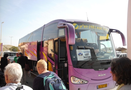
In February 2010, we spent 14 days in Egypt, Jordan, and Israel on a tour arranged by Pilgrim Tours. We left Seattle on Thursday, Feb. 4 and returned Wednesday Feb. 17. |
|
Tour was at a pretty good time. It was warm for most of our visit. It was greener than normal because there had been heavy rain and even floods in Israel and Sinai about two weeks earlier. |
|
There is some dispute about the locations of some of the sites. Hopefully the pictures will give insight into the Bible times. We liked what our guide at the Garden Tomb (one of the sites believed to be Jesus' tomb) said. It was something like this. "This site has many of the characteristics that the site of Jesus' crucifixion and burial should have. Do we know for sure that it is the right site? No. But it doesn't matter. He is not here. He is risen!" |
|
This page gives a quick pictorial index of the places we visited along with an an introduction and summary of the sites. You will also find a few other links to other sites that may be useful. It is recommended that after looking at "Click here for more pictures" for one site, you return to the main page so you can look at the introduction for the next one. |
|
If you notice any errors or serious omissions, PLEASE let us know so they can be corrected. Any other comments would be appreciated as well. brinkje@plu.edu |
|
Maps Quick Index |
The ![]() symbol
beside some selected pictures indicates a larger image is available by clicking the symbol.
symbol
beside some selected pictures indicates a larger image is available by clicking the symbol.
Our tour started with 2 nights in Cairo and 1 night in Sinai which today is part of the country Egypt.
|
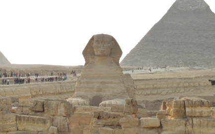
Cairo is one of the world's largest cities with over 20,000,000 residents. There are a lot of contrasts. While driving down a street, one might pass a donkey cart and pedestrians crossing between moving cars. Hopefully you are not the driver, because on a road with 3 marked lanes all one direction, one might find two cars each straddling a lane marker when traffic is light or 4 cars side by side when the traffic is heavy. While in Cairo, we visited the Egyptian Museum, the pyramids and the Sphinx. Click here for more pictures. |
|
After leaving Cairo and crossing under the Suez canal, we visited a couple of oases believed to be visited by the Israelites after they crossed the Red Sea
We had a Sunday morning devotion time while at Marah. At Elim, we met a Bedouin woman.
|
27 Then they came to Elim, where there were twelve springs and seventy palm trees, and they camped there near the water. (NIV, Exodus 15:27) Click here for more pictures. |

|
|
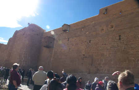
There is some dispute about the location of Mt. Sinai but this one is most traditional. St. Catherine's Monastery
sets at the foot of Mt. Sinai. It was the 7th monastery ever built. (The first 6 were in Egypt.) It includes the
burning bush.
Click here for more pictures. |
|
|
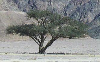
"Acacia tree" wasn't an official stop on the tour. In fact, we didn't even stop to look at one and
Jim had to take pictures from the moving bus. Acacia (or Shittim) wood is mentioned several
times in Exodus and we saw several after leaving Mt. Sinai.
Click here for more pictures. |
After our time in Egypt, we spent two nights in Jordan: The first in Acaba and the second in Amman. In Jordan we visited Petra, Greek Orthodox Church of St. George in the town of Madaba (Medeba), and then Mt. Nebo

|
The desert hills in Jordan like those we saw on the way to Petra can be quite beautiful. We have some observations about Jordan that don't fit with any of the sites discussed below. Click here for comments and pictures. |

|
Petra is an ancient area that was rediscovered and excavated in the last 200 years. The Treasury got its name because people believed it contained a treasure. Instead it was just a grand tomb carved out of sandstone. Click here for more pictures. |
|
In Biblical times, Madaba was known has Medeba and is mentioned in Joshua 13:9 when Joshua was assigning territory to the 2 and 1/2 tribes that settled east of the Jordan. The St. George Church is known for a large mosaic map showing biblical sites known in the Byzantine period (5th century). This pictorial map is the oldest known map of the Holy Land still in existence. The present church was built over the rediscovered map mosaic in the late 19th centrury. But it also has some great pictures like the one shown here. Click here for more pictures. |

|

|
From Mt Nebo Moses looked out at the Promised Land and died there. (Deuteronomy 32:48-52, 34:1-5) Hopefully the visibility was better than when we there. Today the Catholic church is rebuilding an old church at that sight. Apparently the roof or walls were in bad shape but we were told the Mosaic in the floor has been preserved. Click here for more pictures. |
The last 7 nights of our trip were in Israel where we traveled back and forth almost the length of the country.

|
We have some comments about Israel that don't fit with any of the sites discussed below. Click here for comments and pictures. |
|
The first night was in Tel Aviv and we flew out of Tel Aviv at the end of the tour. We got to see the Mediterranean Sea while we were there but otherwise it was just a good place to spend the night. |

|

|
We traveled north to Caesarea which was the location of Herod's primary home and a center of Roman life. It also is noted for being the home of the centurion baptized by Peter (Acts 10:9-48) after his vision about unclean foods. Paul landed in Caesaria after his 2nd and 3rd missionary journeys (Acts 18:22, 21:8). His 4th trip began as he was taken to Caesarea to be tried by Felix and Agrippa before being sent to Rome as a prisoner (Acts 23:23 - 27:2). We saw the remains of the theater, the hippodrome, Herod's palace, the aqueduct and other places. There were also ruins from the Moslem and Crusader periods. Click here for more pictures. |
|
Mt. Carmel was the place where Elijah defeated the priests of Bail (I Kings 18:16-46). There is now a church at this location. The view from the mountain includes an Israeli air base. Click here for more pictures. |

|
|
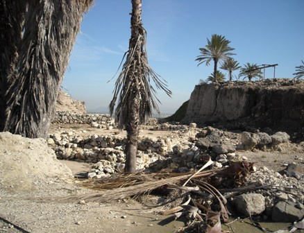
Excavations have found 26 layers representing many different civilizations. It is one of the most excavated sites in Israel. I Kings 9:15 mentions it as part of the construction program that includes the temple in Jerusalem. Because of its strategic location, it was the site of many battles over the centuries from 14th century B.C to World War I. It also suffered from many earthquakes. Remains have been found of stables, palaces, temples, and a water system. The water system includes a reservoir that can be reached by staircase in a shaft about 120 feet deep and then by a horizontal tunnel about 230 feet long. The shaft was inside the walls of the city so water could be obtained even when the area was under siege. The area is sometimes known as Armageddon which may best be remembered for its role in Revelations 16:16 and 17:8-18 where it is the site of a battle where the Lamb defeats the antichrist. Click here for more pictures. |
Nazareth VillageNazareth Village is a combination of excavations and recreations that attempts to show the lifestyle of the people at Jesus time. The picture shows a wine press. They stomped the grapes with their feet in the upper depression in the top right and the juice would run into the middle reservoir and then into the lowest reservoir. The middle reservoir acted like a filter or settling basin. They used their feet in the upper depression to avoid breaking the seeds. Click here for more pictures. |

|
|
We didn't stop at Kfar Kana but it is believed to be Cana of Galilee where Jesus turned water into wine at a wedding (John 2:1-12). For some more information, you can check this or other sources. |

|

|
North of the Sea of Galilee near the borders with Lebanon and Syria, the Jordan River splits into three parts. We traveled to two of them. Major springs supply water to both of them. The first was Dan. Unfortunately, at Dan the northern kingdom set up an altar to idols. In Judges 17 and 18 we read that Micah set up an idol in northern Israel and the tribe of Dan moved there. After Solomon's death, the northern kingdom lead by Jeroboam, rebelled against Solomon's son Rehoboam. In I Kings 12:25 - 32, we read that Jeroboam set up golden calves at Bethel and Dan so his people would not go to Jerusalem to worship. The area is part of the Tel Dan Nature Reserve. The picture shows the tributary of the Jordan at Dan. Click here for more pictures including the remains of the shrine. |
|
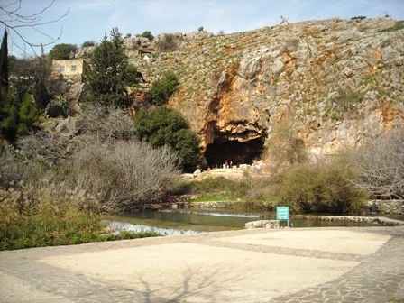
Today the stream from the second of the three headwaters of the Jordan is called Hermon Stream and the area is called Banias. In Jesus day it was called Caesarea Philippi. It is where Peter declared, "You are the Christ, the Son of the Living God." (NIV, Math. 16:16) In response Jesus said "And I tell you that you are Peter, and on this rock I will build my church." (NIV, Math. 16:18) The town was originally founded by the Greeks worshiping "Pan", the Greek God with goat body and human head. Later it became a Roman town. Arab cultures didn't have a "p" in their alphabet so they used a "b" instead. Thus the name "Banias" instead of "Panias". At Jesus' time, water came from a cave. However an earthquake moved the source of the spring. You can see that there is still lots of water coming from the current spring. Click here for more pictures. |
|
We visited several sites around the Sea of Galilee and stayed two nights in Tiberias. (In John 6:23 we read that boats brought people from Tiberias to see Jesus.)
We stopped at the Mt. of the Beatitudes on our way to Dan and Banias. It is believed that Jesus spoke the Beatitudes at this location and Catholics have built a church here.
On the way back from Banias we stopped at Capernaum. Capernaum was an important location in Jesus ministry. When Jesus began teaching, he moved to Capernaum (Matthew 4:13). He cursed it in Matthew 11:23-24 (and Luke 10:15) for unbelief. He taught about giving unto Caesar what was Caeser's in Matthew 17: 24. He healed the paralytic man let down from the roof of a crowded house in this village (Mark 2:1-12). Jesus cast out a demon from a man while teaching here (Mark 1:21-27). He healed the servant of the centurion.(Luke 7:1-10). Capernaum is mentioned 3 times in John 6.
It is believed that Capernaum was the home of Peter, Andrew, James and John. That would mean that Peter's mother-in-law was healed there (Luke 4:38-39). Matthew the tax collector also dwelt here.
In Capernaum a Synagogue has been excavated (but this synagogue was probably built after Jesus' time). It is near a house that second century Christians believed to be Peter's home.
We also had a devotional cruise on the Sea of Galilee and viewed a fishing boat that is dated about the time of Christ.
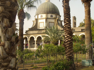
The Church of the Beatitudes |

Ruins of a synagogue in Capernaum |
Click here for more pictures.
|
Some people in our group were baptized in the Jordan river in a site near the Sea of Galilee. Many believe that this is the site where John the Baptist baptized Jesus. (Mathew 3: 13-17, Mark 1: 9-11, Luke 3:21-22) Click here for more pictures. |

|
This city was ruled by Egyptians, Canaanites, Israelites, Greeks, and Romans among others. The excavations of the city are from the Greek and Roman periods. Other civilizations appear on the hill above the city.
This city was given to the tribe of Manasseh when the Israelites returned from Egypt (Joshua 11:11) but the Israelis didn't gain control of it for many years (Judges 1:27-28). It was called Beth Shan at that time. I Samuel 31:8-31 tells us that after the Philistines found Saul and his three sons dead on Mount Gilboa, they fastened his body to the city walls. Israel gained control of the city during the reign of King David or King Solomon and Solomon appointed a district governor at the city (I Kings 4:7-12).
After it became a Roman city called Scythopolis, it was the capital of a region called Decapollis which is mentioned in the New Testament. It is one of the areas where large crowds followed Jesus (Matthew 4:24-25). A man who had been demon possessed began to tell how much Jesus had done for him in Decapolis (Mark 5:18-20). Mark 7:31-35 tells how Jesus healed a deaf and dumb man near this region.
The city was destroyed by an earth quake in 749 AD. See this link for more history of the city.
Click here for more pictures.
|
After leaving Beit Shean, we continued traveling south to the Dead Sea and spent a night there. Actually we spent the night near the evaporation pools where minerals are recovered from the sea. While we were there we spent time at three sites on the west side of the sea. Click here for more pictures. |

|
|
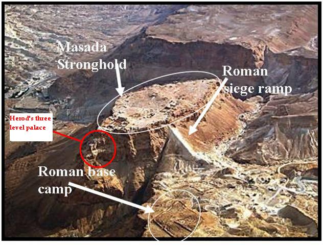
Masada was a desert fortress on top of a mountain built by Herod the Great. It is a boat shaped plateau at about sea level high above the Dead Sea. It is isolated from the surrounding mountain range. Herod created a palace for himself, store house and a water system that collected and stored water from other mountains. When the Jews revolted and the Romans destroyed the temple, some Zealots moved to this fortress. To conquer it, the Romans built a ramp up to the top on the west side. But when it was completed they discovered the Zealots had committed suicide to avoid being taken by the Romans. Because it is impossible to really get the full impression of Masada except from the air, we borrowed this picture from this source and added the note about Herod's palace. Click here for more pictures. |
|
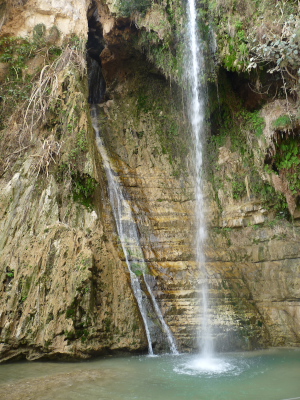
In the mist of a desert with less about 1/4 of rain per year, En Gedi is an oasis that enjoys plant life, has a spring, and is great for growing plants that need a hot climate. It is on the west shore of the Dead Sea about 10 miles north of Masada. Where does the water come from? It comes underground from the places like Jerusalem which is something like 30 miles away that has more rain. The rain soaks into the ground, but it is forced to stay above the solid Basalt rock below the ground. Thus it becomes an underground river flowing to En Gedi. In I Samuel 23:29 - 24:22, we read how David fled to the caves of En Gedi to hide from Saul. At one point Saul went into a cave to relieve himself. It was the same cave in which David was hiding. David cut off a piece of Saul's robe but did not harm him. En Gedi is also mentioned in Joshua 15:62, 2 Chronicles 20:2, Song of Songs 1:14 and Ezekiel 27:10. Click here for more pictures. |
|

|
In 1947 Bedouins shepherds discovered some ancient scrolls in a cave near the north end of the Dead Sea. Additional scrolls have been found since then. It turned out they were copies of the Old Testament, Apocrypha copied by the Essenes. The Essences were ascetics that paid attention to ritual bathing, purity, and communal living. They lived at this site from the 2nd century before Christ to 68 A.D. when they were conquered by the Roman army. Their primary task was copying scriptures and their own books which were put in jars and hidden in caves. The weather at the site helped preserve the books for 2 centuries. Scrolls discovered there have been moved to either the Vatican or the Israel Museum. The picture shows a copy that is on display in the Qumran National Park. Click here for more pictures. |
|
One of the highlights of the tour was a stop at Abraham's tent where father Abraham welcomed us to a camel ride and an "authentic" meal. Strangely Abraham had an English accent and the meal included chicken instead of a native bird. However, the meal was excellent and Father Abraham shared the recipe for the outstanding chicken which included hysop, garlic, sea salt and date honey. In the picture, father Abraham welcomes us to his tent and meal. Most of us sat on mats as was done in Bible times. Father Abraham kindly provided chairs for those who needed them. Click here for more pictures. |

|

|
Bethlehem is about 8 miles south of Jerusalem. In the Old Testament, Bethlehem was the hometown of Ruth's mother-in-law (Ruth 1:1) and of David (1 Samuel 16:1). In Micah 5:2, we read that the Messiah will come from this city. This prophecy came true when it was the birthplace of Jesus. (Matthew 2 and Luke 2). The picture shows part of the santuary in the Greek Orthodox part of the Church of the Nativity. They had lots of hanging candles and insense pots like those shown. Click here for more pictures. |
WOW! We can't find words to describe it.
|

The Garden of Gethsemane |

The Garden Tomb |
Click here for more pictures.
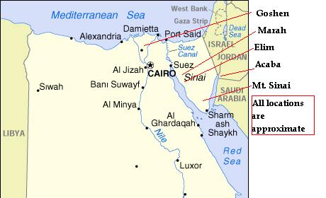
![]()
(The original map was found at a Michigan State University
site but I have ben unable find it again to provide an appropriate reference to it.)
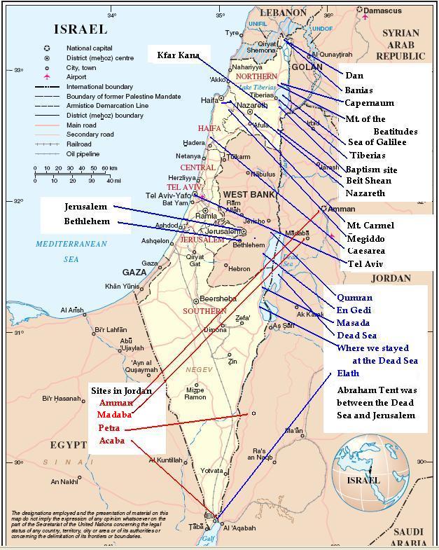
![]()
(This map is based on a map
produced by the United Nations.)
|
Recomnendation: Read the indroduction and summary before looking at the additional pictures. |
||||||||||||||||||||||||||||||||||||||||||||||||||||||||||||||||||||||||||||||||||||||||||||||||||||||||||||||||||||||||||||||||||||||||||||||||
|
||||||||||||||||||||||||||||||||||||||||||||||||||||||||||||||||||||||||||||||||||||||||||||||||||||||||||||||||||||||||||||||||||||||||||||||||
Copyright 2010 James and Danielle Brink. Permission is given for non-commercial use.
Last revision: 4/5/2010, 4/11/2012